
Putting Salmon Creek back in its bed
A large project to reset Salmon Creek away from nearby roads, electrical poles and other infrastructure, stop streambank erosion and the resulting sedimentation and provide space for the creek to go when waters run high has been underway since last fall just north of Lockerby Hill Road.
This is not the more visible streambank stabilization project just upstream of red bridge, though the Tompkins County Soil and Water Conservation District and Lansing’s Highway Department are working together on both projects.
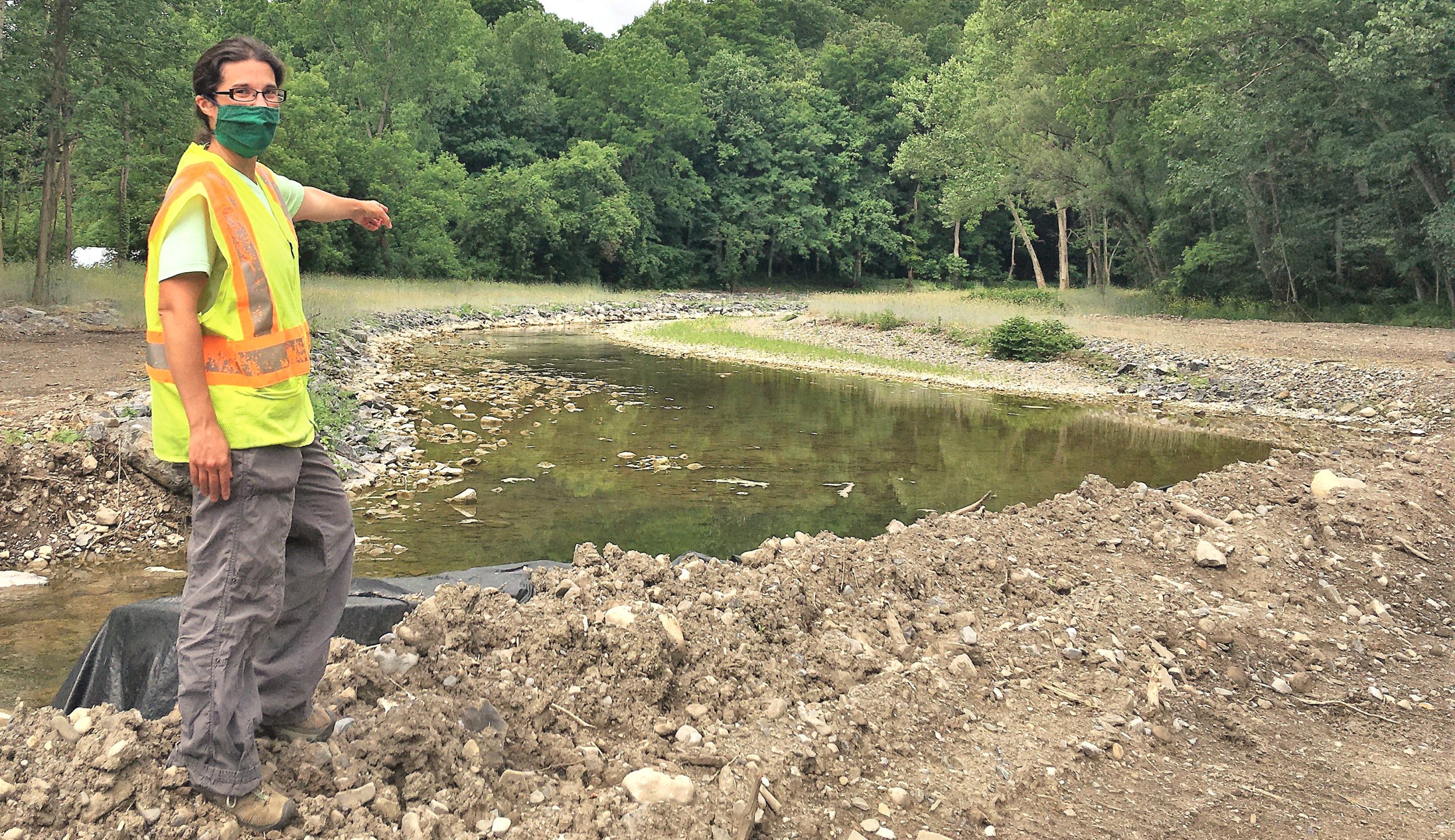
Salmon Creek has naturally meandered to the east, toward Salmon Creek Road, according to Resource Conservation Specialist Angel Hinickle from the Soil and Water Conservation District.
“The highway department brought this to my attention,” Hinickle said. “The stream has been getting really close to the road and is working into a nearby farm. There were eight-to-10-foot-high eroded banks working toward the road. The land owners also asked for assistance as it was getting close to their infrastructure.”
Hinickle said that the channel is not stable and is instead eroding. The project’s aim is to “create a stable stream channel, creating a floodplain bench that allows the stream at flood stage to get out of its banks and onto flood plain, and slow it down.”
The project involves a roughly triangular area about 500 feet by 500 feet about 400 feet to the north of Lockerby Hill Road.
Salmon Creek was dammed with large concrete blocks and filter fabric and then re-routed to keep construction sediment out of the stream’s waters. Large rip rap rocks were then installed to form the new stream bank and stream bed.
Trout fishermen who frequent the area will recognize the “riffle – run – pool – glide” pattern of the rebuilt creek.
“It’s a natural sequence,” Hinickle said. “We will heavily plant to create a ‘riparian buffer’ that will shade the stream bank, holding the bank together and sheltering wildlife.”
The old stream bed is being filled and leveled to form a flood plain. Likewise, the land on the inside of the bend will also be leveled. Both areas will be planted with native grasses and bushes to slow flood waters and resist erosion.
Then, the dams will be taken out and the creek allowed to flow into its new streambed.
“In some areas, like in a forest, we’d leave the stream alone to go where it wants to,” Hinickle said.
The downstream project at the red bridge focuses on undoing the effect of about a dozen fallen trees that channeled the creek’s waters into its banks. Removing the trees will remove the cause of the problem; rip rap rocks will stop the resulting erosion of the streambank.
The channel itself will be returned to its original shape, “a stable cross section for the creekbed,” according to Lansing Director of Planning C.J. Randall.
The Conservation District is a local government entity, Hinickle said.
“It’s not a county agency and it’s not a state agency,” she said. “Every county in the state has a soil and water district supported by state and local funds and some grant money.”
Funding for this project is a combination of contributed labor and equipment from Lansing’s Highway Department and capital from the Finger Lakes – Lake Ontario Watershed Protection Alliance. The Coalition of Soil and Water Districts also has a pool of money for water quality projects, according to Hinickle.
Though Hinickle is overseeing the project on site, the plan came from a retired effluvial geomorphologist from Delaware County, experienced in protecting the source of New York City’s water supply.
“An effluvial geomorphologist is a person who understands the stream and how it changes,” she said.
Hinickle has been with the Conservation District since 2012. She has a bachelor’s degree in environmental science and water resources management from SUNY Geneseo and a masters degree in environmental science and policy from the University of Wisconsin at Green Bay.
The project is scheduled to be complete before summer’s end, Hinickle said.
“We don’t anticipate any issues,” she said. “This is a stable stream.”
Once the plantings mature, this section of the creek should be virtually indistinguishable from those upstream and down.
Related Articles

Local representatives push HEAP as winter nears
Lansing HEAP program applications are now open, helping low-income households cover heating costs and access energy assistance this winter.
Lansing’s $17M capital project advances amid construction challenges
Lansing Central School’s $17M BOBCAT capital project upgrades schools, athletic facilities, HVAC, and infrastructure.